Mid County Parkway Ramona Expressway
Status: Under Construction
Location: Western Riverside County
Type of Project: Expressway
Location: Western Riverside County between San Jacinto and Perris
Type of Project: Highways
OVERVIEW
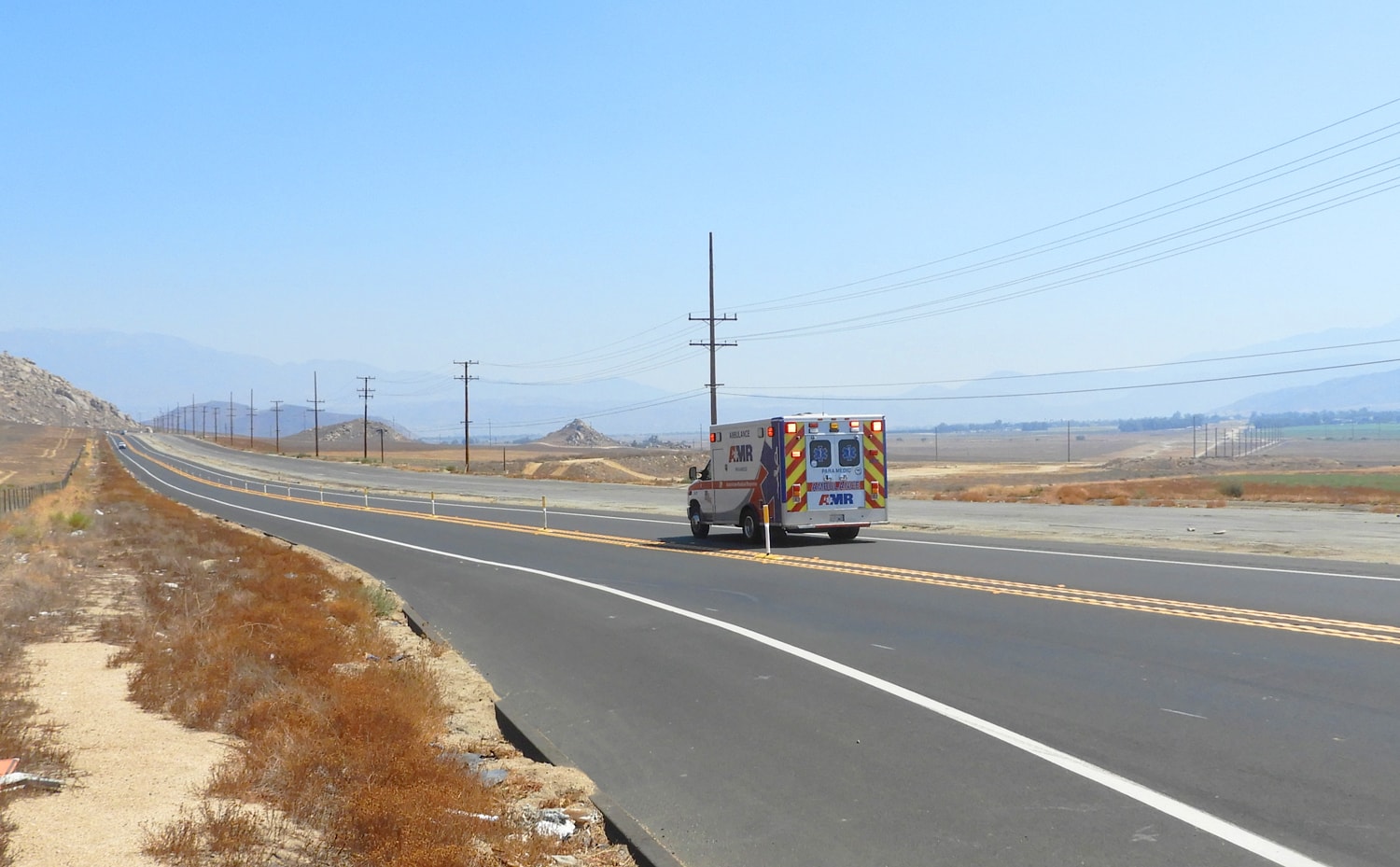
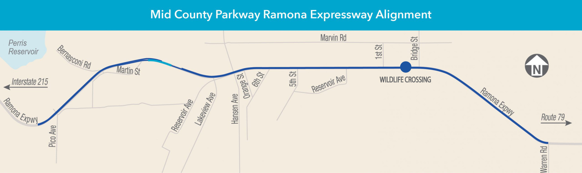
The Riverside County Transportation Commission (RCTC) is conducting safety and road improvements along a major 8.6-mile segment in the County of Riverside. Major roadway improvements will be made along the Ramona Expressway from Warren Road to about one mile east of Rider Street in the County. This segment is within the Mid County Parkway, also known as the MCP, a planned 16-mile corridor between Route 79 in the Hemet Valley and Interstate 215 in Perris. Construction is set to take place from early 2026 to 2028.
The MCP Ramona Expressway experiences a high rate of vehicular collisions. To address the high priority safety and access needs in the area, RCTC has deferred final design of the MCP Segment #1, west of Ramona Expressway. Roadway improvements along Ramona Expressway will include the following:
- An additional travel lane in each direction (one to two lanes)
- A raised median
- Construction of a new bridge over the San Jacinto River
- Traffic signal upgrades
- Construction of a wildlife crossing
These upgrades are designed to improve motorist safety, reduce travel times, and expand access to jobs, education, and transit. The Ramona Expressway serves as a vital link that provides equitable access to multiple modes of travel with connections to SR-79, I-215, and transit facilities that support Metrolink’s 91/Perris Valley Line and Riverside Transit Agency routes.
During construction, periodic lane closures and traffic shifts are expected. Work may take place during daytime, nighttime, and weekends hours. Motorists should plan for extra travel time. Access to homes and businesses will be maintained where possible. Construction alerts will be posted as updates are made available. To receive alerts via email, sign up using the form below.
Final design of the 8.6-mile segment on Ramona Expressway is complete, and construction is set to begin in early 2026 for approximately two years.
RCTC also is working to fulfill its environmental mitigation commitments:
Under the Multi-Species Habitat Conservation Plan, RCTC has acquired more than 177 acres of land to mitigate project impacts to sensitive plants and wildlife.
- RCTC has created a wetland area to mitigate impacts to aquatic resources in order to obtain a permit from the U.S. Army Corps of Engineers.
- RCTC also is preparing a Cultural Landscape Study to mitigate project impacts to historic properties.
- RCTC deferred final design of a previously identified segment from Redlands Avenue north of Placentia Avenue that would have continued east and connected with Ramona Expressway south of Lake Perris, in order to address the high priority safety and access needs along the Ramona Expressway segment.
Construction is expected to take place between early 2026 and 2028.
- July 2009: In response to comments received from the public on the Draft Environmental Impact Report/Environmental Impact Statement (EIR/EIS) for the proposed original Mid County Parkway between Interstate 15 and State Route 79, RCTC takes action to focus the project limits on the portion between I-215 and Route 79.
- January 2013: RCTC recirculates the Draft EIR/EIS for public review for the refocused project.
- January 2014: RCTC recirculates revised sections of the Draft EIR (air quality, greenhouse gases, climate change, and Table 4.10) for public review.
- April 2015: RCTC approves the final EIR for the Mid County Parkway.
- August 2015: The Federal Highway Administration approves the Record of Decision. Following environmental approvals by RCTC and FHWA, RCTC initiates work on the final design of the Mid County Parkway and begins to implement the mitigation commitments stipulated in the Final EIR/EIS.
- November 2016: RCTC awards a design contract for the I-215 Placentia Avenue Interchange.
- July 2017: RCTC prevails in court against a CEQA challenge to the project
- July 2018: RCTC resolves litigation for project
- August 2020: Construction starts on the I-215 Placentia Avenue Interchange in Perris, the first MCP segment.
- June 2022: RCTC defers work on 3-mile segment near Redlands Avenue in Perris in favor of an 8.6-mile segment along Ramona Expressway, due to high priority safety needs on Ramona Expressway.
- Fall 2022: Final design begins on Ramona Expressway segment.
- Fall 2022: I-215 Placentia Avenue Interchange opened.
Environmental Documents
-
- Record of Decision (Aug 2015), click here.
- Final Project Report (April 2015), click here
- Federal Register Notice of Limitations on Claims for Judicial Review of Actions by the FHWA pursuant to 23 U.S.C 139 and other Federal agencies, click here.
Volume I - Chapters 1 - 2 and Chapters 4 - 7
Vol I Cover.pdf – 72.17 KB
1.0 Proposed Project.pdf – 5.30 MB
2.0 Project Alternatives.pdf – 56.48 MB
4.0 CEQA.pdf – 763.30 KB
5.0 Comments and Coordination.pdf – 349.48 KB
6.0 List of Preparers.pdf – 41.99 KB
Master TOC.pdf – 58.38 KB
Summary.pdf – 479.81 KB
Volume 1 - Chapter 3
3.0 Affected Environment.pdf – 17.96 KB
3.1 Land Use.pdf – 93.26 MB
3.10 Water Quality.pdf – 50.72 MB
3.11 Geology-Soils-Seismic.pdf – 3.72 MB
3.12 Paleontology.pdf – 44.54 MB
3.13 Haz Waste-Matls.pdf – 85.52 MB
3.14 Air Quality.pdf – 327.37 KB
3.15 Noise.pdf – 249.59 MB
3.16 Energy.pdf – 41.02 KB
3.17 Natural Communities.pdf – 5.43 MB
3.18 Wetlands.pdf – 1.14 MB
3.19 Plant Species.pdf – 41.32 KB
3.2 Growth.pdf – 663.85 KB
3.20 Animal Species.pdf – 157.51 KB
3.21 Threatened Endangered Species.pdf – 2.09 MB
3.22 Invasive Species.pdf – 27.27 KB
3.23 Relationship Between Local Short.pdf – 22.66 KB
3.24 Irreversible and Irretrievable.pdf – 14.91 KB
3.25 Cumulative Impacts.pdf – 54.77 MB
3.3 Farmlands-Timberlands.pdf – 24.55 MB
3.4 Community Impacts.pdf – 5.92 MB
3.5 Utilities-Emer Ser.pdf – 135.08 KB
3.6 Traffic-Pedestrian.pdf – 680.86 KB
3.7 Visual.pdf – 5.28 MB
3.8 Cultural Resources.pdf – 257.33 KB
3.9 Hydrology and Floodplain.pdf – 21.36 MB
Volume II (Appendicies A-I and Appendicies K-N)
Vol II Cover.pdf – 64.49 KB
App A CEQA Checklist.pdf – 46.36 KB
App B Final Section 4f Evaluation.pdf – 22.72 MB
App C Title VI.pdf – 169.10 KB
App D Summary of Relocation Benefit.pdf – 1.74 MB
App E Glossary of Technical Terms.pdf – 65.19 KB
App F ECR.pdf – 553.95 KB
App G List of Acronyms.pdf – 33.41 KB
App H List of Technical Studies.pdf – 22.01 KB
App I Supplemental Ch 2 Attachments.pdf – 112.68 MB
App K 2012 RTP 2015 FTIP.pdf – 1,003.16 KB
App L USFWS Letters.pdf – 138.12 KB
App M LEDPA.pdf – 50.31 MB
App N Regional Species of Concern and Coverage.pdf – 148.49 KB
Volume II (Appendix J-Supplemental Ch 5 Attachments)
App J Supplemental Ch 5 Attachments.pdf – 92.14 KB
Attachment J-1.pdf – 9.73 MB
Attachment J-2_1.pdf – 2.41 MB
Attachment J-2_10.pdf – 219.89 KB
Attachment J-2_11.pdf – 1.74 MB
Attachment J-2_12.pdf – 8.16 MB
Attachment J-2_13.pdf – 531.94 KB
Attachment J-2_14.pdf – 1.74 MB
Attachment J-2_2.pdf – 2.58 MB
Attachment J-2_3.pdf – 1.95 MB
Attachment J-2_4.pdf – 1.45 MB
Attachment J-2_5.pdf – 13.24 MB
Attachment J-2_6.pdf – 394.75 KB
Attachment J-2_7.pdf – 755.16 KB
Attachment J-2_8.pdf – 3.26 MB
Attachment J-2_9.pdf – 6.31 MB
Attachment J-3.pdf – 17.56 MB
Attachment J-4.pdf – 20.93 MB
Attachment J-5.pdf – 2.87 MB
Attachment J-6.pdf – 5.97 MB
Attachment J-7.pdf – 791.41 KB
Volume III
Vol III Cover.pdf – 64.50 KB
App O Parcel Acquisitions.pdf – 342.94 MB
App P Habitat Mitigation and Monitoring.pdf – 17.19 MB
App Q References.pdf – 73.07 KB
App R Index.pdf – 108.43 KB
App S RTC.pdf – 105.52 MB
App T MSHCP.pdf – 47.66 MB
App U MOA.pdf – 46.78 MB
App V RTC.pdf – 8.22 MB
App W BO.pdf – 662.15 KB
Vol I Cover and Introduction
Volume I Master TOC
Executive Summary
1.0 Purpose and Need
2.0 Alternatives
3.0 Affected Environment
3.1 Land Use
3.2 Growth
3.3 Farmlands-Timberlands
3.4 Community Impacts
3.5 Utilities-Emer Ser
3.6 Traffic-Pedestrian
3.7 Visual
3.8 Cultural Resources
3.9 Hydrology and Floodplain
3.10 Water Quality Storm Runoff
3.11 Geology-Soils-Seismic
3.12 Paleontology
3.13 Haz Waste-Matls
3.14 Air Quality
3.15 Noise
3.16 Energy
3.17 Natural Communities
3.18 Wetlands
3.19 Plant Species
3.20 Animal Species
3.21 Threatened-Endangered Species
3.22 Invasive Species
3.23 Relationship
3.24 Irreversible and Irretrievable
3.25 Cumulative Impacts
Cover (70 KB)
Appendix A: CEQA Environmental Checklist (115 KB)
Appendix B: Revised Draft Section 4(f) Evaluation (13.5 MB)
Appendix C: Title IV Policy Statement (115 KB)
Appendix D: Summary of Relocation Benefits (530 KB)
Appendix E: Glossary of Technical Terms (65 KB)
Appendix F: Environmental Commitments Record (620 KB)
Appendix G: List of Acronyms (35 KB)
Appendix H: List of Technical Studies (25 KB)
Appendix I: Supplemental Chapter 2 Attachments (2 MB)
Appendix J: Supplemental Chapter 5 Attachments – part 1 of 2 (47 MB)
Appendix J: Supplemental Chapter 5 Attachments – part 2 of 2 (30 MB)
Appendix K: 2012 RTP and 2011 FTIP (Amendment 24) Project Listings (215 KB)
Appendix L: USFWS Letter (265 KB)
Appendix M: 404 (b)(1) Alternatives Analysis (4.5 MB)
Appendix N: Regional Species of Concern and Coverage under the Western Riverside County Multiple Species Habitat Conservation Plan (140 KB)
Appendix O: Parcel Acquisitions (4.5 MB)
Appendix P: Conceptual Mitigation Plan (140 KB)
Appendix Q: References (95 KB)
Appendix R: Index (160 KB)
- Addendum to the Community Impact Assessment (January 2012; 21 MB)
- Air Quality Analysis (March 2012; 7 MB)
- Archaeological Evaluation Proposal (November 2007)
Contact RCTC: Confidential Content - Community Impact Assessment (June 2008; 150 MB)
- Draft Preliminary Drainage Report (March 2011; 37 MB)
- Draft Project Report (November 2012; Approved January 2013; 2 MB)
Attachments:- Cover / List of Attachments (210 KB)
- Attachment AA (1 MB)
- Attachment B (2 MB)
- Attachment C (3 MB)
- Attachment D (8 MB)
- Attachment E (16 MB)
- Attachment F (27 MB)
- Attachment G (4 MB)
- Attachment H (260 KB)
- Attachment I (2 MB)
- Attachment J (2 MB)
- Attachment K (2 MB)
- Attachment L (5 MB)
- Draft Relocation Impact Report (December 2011; 700 KB)
- Extended Phase I Survey Proposal (May 2007)
Contact RCTC: Confidential Content - Finding of Effect (November 2012)
Contact RCTC: Confidential Content - Hazardous Waste Initial Site Assessment (July 2011; 7 MB)
- Historic Property Survey Report (June 2012)
Contact RCTC: Confidential Content - Natural Environmental Study (July 2008; 146 MB)
(Appendicices A-R) Jurisdictional Delineation Report (May 2007; revised February 2008):- Cover / Table of Contents (25 KB)
- Appendix A (46 MB)
- Appendix B (170 KB)
- Appendix C (175 KB)
- Appendix D (22 MB)
- Appendix E (10 MB) / Data Sheets (22 MB)
- Appendix F (5 MB)
- Appendix G (6 MB)
- Appendix H (35 MB)
- Appendix I (5 MB)
- Appendix J (2 MB)
- Appendix K (6 MB)
- Appendix L (410 MB) / Data Forms (49 MB)
- Appendix M (98 MB)
- Appendix N (3 MB)
- Appendix O (75 KB)
- Appendix P (255 KB)
- Appendix Q (295 KB)
- Appendix R (27 MB) / Data Sheets (20 MB)
- Noise Abatement Decision Report (April 2012; 19 MB)
- Noise Study Report (January 2012; 161 MB)
- Paleontological Resources Identification and Evaluation Report (March 2008; 494 MB)
- Preliminary Geotechnical Design Report for the Project Report and Environmental Document (March 2008; 43 MB)
- Preliminary Recommendations of Eligibility and Level of Effects Report (July 2008)
Contact RCTC: Confidential Content - Storm Water Data Report (October 2011; 11 MB)
- Summary of Floodplain Encroachment (September 2011; 145 MB) Includes: Location Hydraulic Studies
- Supplemental Extended Phase 1 Proposal (October 2007)
Contact RCTC: Confidential Content - Supplemental Paleontological Resources Identification and Evaluation Report (September 2011; 47 MB)
- Supplement to the Natural Environment Study (December 2011; 33 MB) Includes: Potential Impacts of Alternatives to Waters of the United States, Riparian Ecosystems, and Threatened and Endangered Species (October 2011) and Supplemental Jurisdiction Delineation Report (October 2011)
- Errata Memorandum for the Supplement to the Natural Environment Study (November 2012; 2 MB)
- Traffic Technical Report (February 2012; 23 MB)
- Visual Impact Assessment (August 2011; 19 MB)
- Water Quality Assessment Report (6 MB)